
Figure 1: Geographic location of Santa Catalina Island, one of the eight Channel Islands off the southern California coast, relative to western North America.
NOTE:The following paper was originally published in the International Journal of Marine Geodesy. The complete text is provided below for Internet access. The graphics accompanying this text may differ from the original illustrations as published. This article may be cited as follows:
Bushing, W. W., 1997. GIS-based gap analysis of an existing marine
reserve network around Santa Catalina Island. International Journal of Marine
Geodesy 20(2-3):205-234.
GIS-BASED GAP ANALYSIS OF
AN EXISTING MARINE RESERVE NETWORK
AROUND SANTA CATALINA ISLAND
William W. Bushing
Ecology, Evolution and Marine Biology
University of California
Santa Barbara, CA 93106
bushing@lifesci.ucsb.edu
and
Vice President
Santa Catalina Island Conservancy
P. O. Box
2739
Avalon, CA 90704
(310) 510-1421 (voice)
(310) 510-1451 (fax)
ABSTRACT
This study utilized a GIS (geographic information system) to evaluate an existing network of marine reserves around an island off the southern California coast. The investigation focused on the effectiveness of the reserve network relative to the regional ecology, the disturbance regime and metapopulation biology of giant kelp (Macrocystis pyrifera), perhaps the most important single taxon in this nearshore marine ecosystem. Macrocystis serves both as structural habitat and food for a wide range of marine invertebrates and fishes. Santa Catalina Island's highly-dissected, 87-km leeward and windward coastline offers a wide range of microhabitats with respect to storm exposure, temperature, the nearshore light regime and other factors. GIS data layers used to address these issues included a digital terrain model, digital bathymetric model, submarine slope, submarine aspect, bottom relief, significant wave height, and kelp distribution maps from several survey years. GIS overlay methods applied to the multi-temporal kelp distribution maps generated a model representing the spatial persistence of kelp. Correlations between the observed distributions, kelp persistence, the disturbance regime and the physical variables that permit kelp to resist or recover from it were drawn. Definite geographic patterns were observed relative to several of these variables. The results in this study are discussed in light of previous research using GIS data layers of sea surface temperature (SST) and a series of solar insolation models. This gap analysis identified large regions of persistent kelp, under disturbance regimes markedly different from those in the existing reserves, that were relatively unprotected. This suggests the designation of additional reserves may be necessary in these currently unprotected areas.
KEYWORDS: Geographic information system, GIS, gap analysis, marine reserves, Macrocystis pyrifera, giant kelp, persistence, Santa Catalina Island, California.
INTRODUCTION
Giant kelp (Macrocystis pyrifera) is a marine alga found along the Pacific coast of North America from central California to Baja California (Abbott and Hollenberg 1976). Although it begins life as a microscopic spore at the ocean floor, this species may grow to lengths of 60 m with its upper fronds forming a dense canopy at the surface. Giant kelp prefers depths less than 40 m, temperatures less than 20 C, hard substrate, and bottom light intensities above 1% that of the surface (North 1971, Foster and Schiel 1985). Macrocystis plays an important role in the marine environment by providing food and habitat for a wide range of marine invertebrates and fishes in southern California. Forests of giant kelp may support millions of individual organisms and more than 1,000 species of marine plants and animals (North 1971, Earle 1980, Foster and Schiel 1985).
Santa Catalina Island is one of the eight Channel Islands located off the southern California coast (figure 1). The island is oriented in a NW-to-SE direction relative to the prevailing westerly and northwesterly swell and wind (figure 2). This orientation results in a high energy exposed coastline on the southwest-facing windward side and a lower energy, more protected environment on the northeast-facing leeward side. In addition, the island's 87-km coastline is highly dissected with small bays, points and other coastal features. Combined, these geographic characteristics result in a wide range of microhabitats with respect to storm exposure, temperature, light and other environmental parameters.
Gap analysis (Scott et al. 1993) has become a popular method of evaluating the degree of protection afforded a species, or a habitat, by an existing network of protected areas (e.g., parks, reserves). The geographic distribution of the species or habitat is compared with the spatial configuration of reserves, and gaps in the coverage relative to the characteristics of the landscape and the target's ecology are identified. Geographic information systems (GIS) are tools often employed in such analyses.
Most of southern California's giant kelp is found along the coasts of the offshore Channel Islands, including Catalina. Anecdotal and personal observations suggest reductions in the distribution of Macrocystis around this island over the past 25 years. Similar trends have been noted elsewhere in the region, and have been attributed to sewage pollution, sea otter hunting, sea urchin grazing, elevated temperatures associated with El Niño events, and other causes (Hodder and Mel 1978; Neushul Mariculture Inc. 1981; Harger 1983; North 1991).
The loss of kelp, and the important marine habitat that it represents, has been one factor stimulating interest in the establishment of marine reserves around Catalina Island. Several existing reserves have already been designated based largely on recreational or educational access. These include Lover's Cove and Casino Point designated by the City of Avalon, Toyon Bay (Catalina Island Marine Institute) and a reserve at Blue Cavern Point associated with USC's Wrigley Marine Science Center at Big Fisherman Cove (figure 3). The California State Water Resources Control Board has also designated stretches of the island's coastline as Areas of Special Biological Significance (ASBS) affording some additional protection (SWRCB 1979, 1981).
With the exception of the Farnsworth Bank ASBS, these reserves are all
located on the leeward side of the island near existing population centers.
Island-wide studies using a geographic information system (GIS) have indicated
the island's most productive kelp beds are located on the more exposed windward
coast (Bushing 1994). This suggests that selection of future marine reserves
should be done on the basis of ecological criteria such as metapopulation
characteristics, disturbance and persistence, rather than strictly on issues of
access or recreational value.
Figure 1: Geographic location of Santa Catalina Island, one of the eight Channel Islands off the southern California coast, relative to western North America.
This study utilizes the same GIS to elaborate on the preliminary research referenced above. New data layers include models of wave and storm exposure, solar insolation and the persistence of kelp around the island which offer a better understanding of ecological disturbance factors and the ability of kelp to recover from them. The persistence layer incorporates multi-temporal kelp maps allowing the analysis of kelp distribution over time relative to the other variables.
Ecologically, the term disturbance has been defined as the discrete
removal of individual organisms from a biological population, a detectable
change in population response to sudden changes in resources, or an event
causing a community or ecosystem characteristic (e.g., species
diversity) to diverge from its normal range (Forman and Godron 1983, Bazzaz
1983, Wallace 1990, Gore et al. 1990). Removal of kelp plants by
storms is an example of the first, reductions in growth or biomass due to
elevated El Niño temperatures the second, and decreases in species
diversity of the marine invertebrates associated with kelp the third. The
"disturbance regime" includes the type, areal extent, magnitude, frequency,
predictability and turnover rate of disturbance events through time within a
given landscape (Forman and Godron 1983, Sousa 1984), and is relative to the
characteristics of both the local landscape, and the species of interest.
Environmental factors influencing the disturbance of Macrocystis may
be biological or physical in nature.

Figure 2: Santa Catalina Island is oriented in a NW-to-SE direction relative to the prevailing westerly and northwesterly winds and swell which directly impact its southwest-facing windward side. Occasional summer chubasco storms strike this coast from the south to southwest. The more protected leeward coast may also be impacted by seasonal Santa Ana storms.
Biological factors include grazing by invertebrates or fish, competition from other algae, encrusting growth and diseases (North 1971, Foster and Schiel 1985). Sea urchins are often cited as agents of disturbance in kelp bed systems globally (e.g., Mann and Breen 1972; Lawrence 1975, Hagen 1983) and in southern California (e.g., Leighton et al. 1966, North and Pearse 1970, Tegner 1980), and several species are known from Catalina waters. Based on other studies (Harrold and Reed 1985, Ambrose et al. 1993), conditions around Catalina are generally favorable for sea urchin overgrazing due to low nutrients, warm temperatures and exposure to storms on the windward side. However, overgrazing events noted on the other Channel Islands (Richards et al. 1993, Ambrose et al. 1993) are rarely observed in Catalina waters based on published reports (Engle 1994, McAlary and McFarland 1994) and personal observations. Macrocystis pyrifera exhibits such strong competitive advantage over other local algae that competition is rarely a problem (Dayton et al. 1992).
The absence of significant local biotic disturbance makes physical factors of primary importance (North 1968, 1971; Foster and Schiel 1985). Warm water episodes such as El Niño have serious effects on the growth and survival of giant kelp (e.g., Dayton and Tegner 1984, Gerard 1984). These large-scale events play a role in the disturbance regime directly through the physiological stress associated with elevated temperature, or indirectly due to associated phenomena (e.g., reduced nutrients or strong storms). On a local scale, exposure to wind, waves, swell and storm events plays an important role in Catalina's disturbance regime. Storms impact the island's windward side primarily from the NW or W during winter, but may also strike from the south during summer or on the leeward side during Santa Ana winds.
A species' response to such disturbance events determines its ability to persist locally through time. Ecological persistence may be simply defined as the absence of local extinction (Rabinowitz et al. 1989) or the continued existence of a species over time (Connell and Sousa 1983). Two components of a species' stability are resistance, the ability to withstand disturbance, and resilience, the ability to return to its pre-disturbance state (Connell and Sousa 1983). The spatial heterogeneity of the physical habitat may play a significant role through the presence of microhabitats serving as refugia (Sousa 1984), high complexity (Pearsons and Li 1992), high nutrient supplies (Steinman et al. 1991) and other factors.
This study utilizes a GIS to identify environmental factors that appear
to confer higher persistence for kelp around Catalina. The physical disturbance
regime is characterized based on available data and models. Multi-temporal kelp
distribution maps are used to generate a model of persistence, and statistical
correlations are drawn to determine the environmental factors which may
contribute to kelp's stability geographically. It is hypothesized that in
regions of higher disturbance kelp will favor sites in protected coastal
aspects, deeper water, shallower slopes and higher bottom relief and show
higher persistence there. Finally, this information will serve to identify gaps
in the existing marine reserve system, and generate guidelines for identifying
optimal kelp beds suitable for designation as future marine reserves.

Figure 3: Existing marine reserves are largely located on the island's leeward coast. These include Lover's Cove and Casino Point (designated by the City of Avalon), Toyon Bay (Catalina Island Marine Institute), and a reserve at Blue Cavern Point associated with the University of Southern California's Wrigley Marine Science Center at Big Fisherman Cove. Some additional protection has been afforded by the Areas of Special Biological Significance (ASBS) designated by the State of California Water Resources Control Board. .
METHODS
Topographic GIS Data Layers (Depth, Aspect and Slope)
GIS data layers required to address the issues in this study include several kelp bed distribution maps, bathymetry (depth), submarine aspect, submarine slope, bottom relief, solar insolation and significant wave height. Data layers were all registered to base maps of the island's shoreline manually digitized (using UTM-11 coordinates) from the four USGS 7.5' quad maps covering Santa Catalina Island at a scale of 1:24,000. Topographic contours were manually digitized from the same maps at 15-76 m (50-250') intervals depending on local topography. Bathymetric contours to a depth of 183 m (100 fathoms) were digitized from NOAA chart 18757 ("Santa Catalina Island"). A digital terrain model (DTM) was interpolated from the combined topographic and bathymetric contours at 20 m resolution to coincide with the spatial resolution of the SPOT satellite imagery used. Submarine aspect and slope data layers were generated from the resulting DTM. Software employed included PC ARC/Info (version 3.4.2), IDRISI (version 4.1) and ERDAS (version 7.5).
Kelp Bed Distribution and Persistence Levels
This research updates previous work in which a single kelp distribution map (Bushing 1994) and a series of four maps (Bushing 1995) were employed. The distribution map used in the initial studies, dated about 1980, was provided by Southern California Edison, the regional electric utility. Distribution data for 1934 were obtained from NOAA's National Ocean Survey database and converted to GIS vector point format. Polygon buffers were created at a distance of 60 m from each point in this data. Kelp bed polygons were manually digitized from a 1977-78 kelp distribution map identified in a field survey (SWRCB 1979). Distribution for 1989 was established using a hard copy map based on an aerial photographic survey conducted by the California Department of Fish and Game provided by Kelco, Inc. Kelp presence in 1990 was generated using a raster-to-vector conversion of a SPOT satellite image in the near infrared (NIR). Kelp's high reflectance and water's strong absorption in the NIR allowed the delineation of kelp canopy in the satellite image using image processing techniques to create a distribution map. Satellite imagery has been employed for kelp surveys, but it is difficult to detect beds smaller than 10 hectares and canopy of low density or entirely submerged (see Jensen et al. 1976, 1979, 1980, 1987; Belsher and Mouchot 1990, 1992; Augenstein et al. 1993; Deysher 1993). McAlary and McFarland (1994) have noted distinct differences in the degree of surface canopy formation at selected sites around Catalina Island.
All five distribution maps (figure 4) were converted to binary raster data layers indicating presence (1) or absence (0) of kelp in each. The five layers were then composited using GIS overlay methods so each cell in the resulting "persistence" layer represented the number of survey years in which kelp was found at that geographic position. The resulting values ranged from 0 (kelp present in no survey years) to 5 (kelp present in all five survey years). A similar method has been used by Southern California Edison to look at the persistence of kelp near its San Onofre generating plant (Albert Lin, pers. comm.).
Bottom Relief
Because bottom relief is a potentially important factor for kelp distribution, GIS layers representing indices of relief were generated. The submarine aspect layer was re-classed into twenty-four 15-degree categories (e.g., 0-14). The resulting image was imported into ERDAS image processing software and rectangular "diversity" or "texture" (Star and Estes 1990) filters were applied at several pixel dimensions (3x3, 5x5 and 10x10) to model the heterogeneity in the region of each raster cell. The variable dimensions of the spatial filters permitted the incorporation of a bottom relief index at three separate spatial scales (30-40, 50-70 and 100-140 m respectively) from the subject cell.
Texture analysis, the application of spatial filters to ecological landscapes, has become popular with the emergence of GIS and image processing as tools for the biologist. It offers one means of quantifying landscape characteristics for subsequent analysis. These techniques have been used to calculate measures of landscape heterogeneity, habitat diversity and habitat fragmentation (e.g., Weaver and Kellman 1981, Ripple et al. 1991)
Storm Exposure
Storm exposure was incorporated into the GIS from a model developed by O'Reilly and Guza (1993) employing submarine bathymetry and swell characteristics to estimate significant wave heights (Hs) in the southern California Bight. Hs is defined as the mean height of the largest 1/3rd of observed waves (Pond and Pickard 1983). An image modelling Hs at 200-m resolution for a peak storm event on March 12, 1995 (1048 PST) was re-created by William O'Reilly and provided for this analysis (figure 5). The image was then printed in color at a scale that permitted digitization of the boundaries between Hs values into vector polygons encoded with the corresponding Hs value. These polygons were registered to the base layers and incorporated into the GIS, and also converted to raster data for cell-by-cell analysis.
Because kelp canopy responds to wave energy as well as wave height, Hs (m) was also quantized into three wave energy levels based on the following equation from Pond and Pickard (1983):
E = ( * g * Hs2)/8
where E is wave energy in Joules/m2, is density and g is 9.8
m sec-2. Since wave energy is proportional to the square of
Hs, values of Hs < 1.40 were assigned to energy level
1, 1.40 < Hs < 2.00 to level 2, and Hs > 2.0 to
level 3. These classes permitted statistical analysis of differences in slope
and depth as a function of Hs and wave energy.

Figure 4: Individual kelp bed distribution maps for five survey years for the region surrounding the extreme west end of the island. These data cover the years 1934 (National Ocean Survey, point vector data, courtesy NOAA), 1979 (Areas of Special Biological Significance survey, mapped product), 1980 (Southern California Edison, vector polygon data, courtesy SCE), 1989 (California Department of Fish & Game, mapped product), and 1990 (SPOT satellite image, 20-m raster data, image courtesy SPOT Image Corp.) .
Data Analysis
Many of the data layers were stored both as polygon and raster data to facilitate the analyses in this study at differing spatial scales. The analyses here focus only on the West Catalina USGS quad. The shoreline for this quad was classified into two primary geographic regions (West windward and West leeward), as well as four subregions (W-SW and W-SO on the windward side and L-NO and L-NE on the leeward side) based on the prevailing direction each coast faced.
Although analysis was conducted using the vector polygon layers, much of the information presented here looked at the data on a cell-by-cell basis due to the influence of smaller-scale (~20-m) heterogeneity on kelp distribution. Binary raster masks representing kelp distribution from the individual temporal surveys were created at 20-m resolution from the original polygon data for both leeward and windward coasts. Unless otherwise stated, all statistics for single year distributions reference the 1980 SCE dataset. The 36.6 m (20-fathom) bathymetric contour was chosen to define the maximum expected depth limit for kelp. The region along the ocean floor between this depth contour and the shoreline represents the potential area that might be occupied by kelp. For this study it is referred to as the "photic shelf" since its lower limit is generally considered to be light-limited. A second set of binary masks, corresponding to the "photic shelf" on the leeward and windward coasts, was created.
Coincident data was extracted from the raster GIS data layers for submarine aspect, depth, slope, bottom relief, and significant wave height using the kelp and photic shelf binary masks and GIS overlay techniques. These data were analyzed within the GIS, and imported into separate Foxpro databases representing the windward and leeward sides. Each data layer (e.g., binary kelp distribution mask, extracted aspect, persistence) was imported as a separate field in the database so each record represented a single geographic location incorporating the associated data in multiple fields. Several programs were written in the xBASE computer language to further analyze the data on a cell-by-cell basis.
Two important statistics were evaluated for each data layer: kelp frequency and kelp percent cover. In this paper the phrase "kelp frequency" refers to the percentage of total kelp along each coastline with a given data level (e.g., 5% of all kelp on the West leeward coast was found at a depth of 18 m). The phrase "percent cover" refers to the percent of the corresponding "photic shelf" covered by kelp for a given value of an environmental variable (e.g., 20% of all 8 m depths on the West windward coast were covered by kelp).
Data were also imported into a statistics package (SYSTAT version 5.02)
for further analysis and graphical presentation. Statistical tests were run on
the data to determine which environmental factors were correlated with the
persistence of kelp on the two coasts (Pearson correlation matrices), and
whether there were statistically significant differences between persistence
levels (pairwise mean Tukey HSD comparisons) based on the methods of Wilkinson
et al. 1992. Simple means testing between populations was based on
Bishop (1984).

Figure 5: Image representing a model of significant wave height (H-s) in the Southern California Bight (Point Conception to the Mexican border) for a peak storm event on 12 March 1995 with an inset of Santa Catalina Island at 200-m horizontal resolution in the lower left corner (image courtesy of William O'Reilly).
RESULTS
Topographic GIS Data Layers (Submarine Aspect, Depth and Slope)
Submarine Aspect
Kelp frequency and kelp percent cover as a function of submarine aspect
are presented graphically for the West Catalina leeward and windward coastlines
(1980 data). Due to the prevailing NW-to-SE trend of the island, the frequency
distribution (figure 6a) shows strong peaks at 0-40 on the north- and
northeast-facing leeward side, and 210-250 on the south- to southwest-facing
windward side. When distribution relative to aspect is analyzed in terms of
percent cover, a different picture emerges (figure 6b). Marked peaks are
observed at ~120 and 300-330 on the leeward side, and 50-90 on the windward
side.

Figure 6a: Polar graph of kelp frequency in percent (radius) as a function of coastal aspect (angle) for kelp along the west windward and leeward coasts in the 1980 SCE survey year. Due to the prevailing NW-to-SE trend of the island, the frequency distribution shows strong peaks at 0-40 degrees on the north- and northeast-facing leeward side, and 210-250 degrees on the south- to southwest-facing windward side.

Figure 6b: Polar graph of kelp percent cover (radius) as a function of coastal aspect (angle) for kelp along the West windward and leeward coasts in the 1980 SCE survey. Marked peaks are observed at ~120 and 300-330 degrees on the leeward side, and 50-90 degrees on the windward side, representing aspects which are atypical given the prevailing coastal direction on each side.
Depth
Depth data were also presented for the leeward and windward coasts
(1980 data). Kelp frequency distribution (figure 7a) on the leeward side peaked
at statistically significant (p < 0.001) deeper depths than on the windward
side. Mean and maximum depth values were 11.6 and 41.8 m on the leeward side
versus 7.1 and 24.1 m on the windward side. Percent cover (figure 7b) also
indicated the same pattern with maximum values at deeper depths on the leeward
side (8-9 m) than the windward (3-5 m).

Figure 7a: Kelp frequency (percent) graphed as a function of depth (meters) for kelp in the 1980 SCE survey along the west leeward and windward coasts. Note that kelp frequency on the leeward coast peaks at statistically significant ( p < .001) deeper depths than on the windward side.
Figure 7b: Kelp percent cover graphed as a function of depth (meters) for kelp in the 1980 SCE survey along the west leeward and windward coasts. Percent cover also exhibited peak values at deeper depths on the leeward (8-9 m) than the windward (3-5 m) side.
Submarine Slope
Figure 8 depicts the results for kelp frequency and percent cover
relative to submarine slope. Kelp frequency also shows statistically
significant differences (p < 0.001) with kelp found on shallower slopes on
the windward side than the leeward. Mean values were 5.8 ± 2.9 on the
windward side and 7.5 ± 3.6 on the leeward. Percent cover shows
generally higher values at lower slopes on both coasts, but an avoidance of
steep slopes on the windward side.

Figure 8a: Kelp frequency (percent) graphed as a function of submarine slope (degrees) for kelp in the 1980 SCE survey along the west leeward and windward coasts. Kelp frequency peaked at lower slope values (4-7 degrees) on both coasts, suggesting the value of more gradual shelf slopes in dissipating energy from incoming swell and surge.
Figure 8b: Kelp percent cover graphed as a function of submarine slope (degrees) for kelp in the 1980 SCE survey along the west leeward and windward coasts. Percent cover showed a general decline with increasing slope on the leeward coast, but a marked decline on the windward coast. This is consistent with expectations that kelp in the higher energy windward environments might benefit more from sites characterized by gradual slopes which dissipate swell and surge energy.
Kelp Bed Distribution and Persistence Levels
The 5-year persistence model is illustrated by figure 9 showing the
results on the extreme West End of the island. It can be seen from the legend
that very few 20-m raster cells had kelp present in all five survey years. In
previously reported results (Bushing 1995) 4-year persistence was analyzed for
only those cells in which kelp was found during the 1980 survey. In that study,
mean persistence on the exposed windward side (2.38) was significantly (p
<< 0.001) higher than for the more protected leeward side (1.83), and
most (78%) of the windward kelp was at higher persistence levels (2-3), than on
the leeward side where 85% was in the lowest persistence levels (1-2).
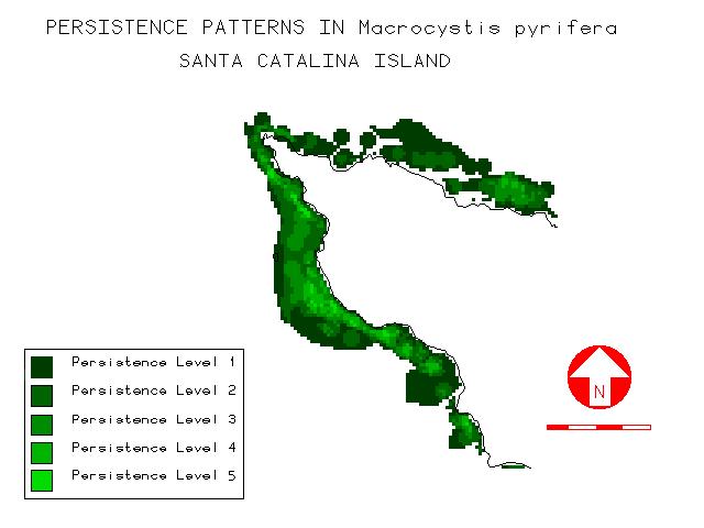
Figure 9: The five-survey persistence model for the extreme west end of the island. Each cell represents a 20-m x 20-m region of the nearshore shelf. Cells with lower persistence (kelp present in fewer survey years) are darker green, while those representing high persistence (kelp present in 4 or 5 survey years) are lighter green.
In the new 5-year persistence model, windward and leeward persistence was compared for each of the 5 survey years, and for all raster cells in which kelp was present in at least one survey year (ie, persistence level 1). In each of the five survey years, mean persistence on the windward side was significantly higher (p << 0.001) than that of the leeward side. Considering all cells with persistence values 1, mean persistence on the windward side (µ = 1.71) was significantly higher (p << 0.001) than that of the leeward side (µ = 1.41). In this analysis, 18.9% of kelp on the windward side exhibited persistence values 3 whereas only 8.7% of kelp on the leeward side fell into these categories.
Bottom Relief
Visually, kelp appeared to have a strong affinity for regions of increased bottom relief such as offshore reefs and areas around coastal points and headlands as illustrated in the region near Arrow Point (figure 10). Although the mean values relative to bottom relief were lower on the windward side, kelp frequency peaked at higher values (6-8) there than on the leeward side (4-7). The mean values were significantly higher for kelp than for the corresponding shelf on both sides, but test statistics indicate the relationship was stronger for the windward side (p < 0.001) than the leeward side (p < 0.010). There were also detectable trends in average bottom relief relative to aspect as presented in Figure 11.
The presentation of kelp percent cover data is more revealing (figure
12). The leeward side exhibits a more uniform distribution (10-20%) relative to
bottom relief. No prominent peaks are noted, although there is a slight trend
for increasing percent cover with increasing bottom relief. On the windward
side, percent cover was low (0-10%) in regions of low bottom relief (1-5),
quite variable (7-22%) at moderate relief (6-16) and exhibited strong peaks
(30-45%) in regions of high relief (17-19). Similar trends were noted at all
three spatial scales.

Figure 10: Modelled bottom relief (10 x 10 pixels) for the nearshore waters off Arrow Point on the island's West End. Cells that are darker gray represent regions with relatively unchanging bottom topography and therefore little relief, while the lighter gray cells represent regions of high relief such as coastal points, headlands, and offshore reefs. Kelp polygons from the 1980 SCE survey year are shown overlain as black outlines. This visualization of the two data layers suggests that kelp has a strong affinity for regions of increased bottom relief, at least at the spatial scale modeled.

Figure 11a: Kelp frequency (percent) graphed as a function of the 10 x 10 bottom relief index (unitless) for kelp in the 1980 SCE survey along the west leeward and windward coasts. Frequency peaks at lower values (4-10) along both coasts.

Figure 11b: Kelp percent cover graphed as a function of the 10 x 10 bottom relief index (unitless) for kelp in the 1980 SCE survey along the west leeward and windward coasts. Percent cover on the leeward side indicates a moderate increase with increasing bottom relief. However, on the windward side, sharp peaks in percent cover at higher bottom relief values (11-15) suggest the potential protection afforded by sites with high bottom relief in the higher energy environments there.
Storm Exposure
A casual glance at the significant wave height (Hs) image for March 12, 1995 (figure 5), confirms the expected difference between the exposed windward and protected leeward coasts. Closer inspection also reveals the development of strong "swell shadowing" on the southern portions of the windward coast, and to a lesser extent along that portion of the West windward coast that faces almost directly south (W-SO).
The frequency distribution for kelp on the windward and leeward sides relative to Hs is consistent with these general patterns (figure 13a). About 90% of kelp on the leeward side was found at lower values of Hs (0.24-1.41 m). On the windward side, the distribution fell into two ranges (1.41-1.70 and 2.21-2.62 m), reflecting the south and southwest exposures along this coastline, with nearly 70% of the kelp in the upper range.
Percent cover of kelp (figure 13b) showed some significant divergence from the frequency distribution. On the leeward side, values were higher (11-32%) at moderate (0.77-1.41 m) and high (3.61 m) values of Hs while on the windward side the highest percent cover (17%) was near the lower Hs range (1.41 m).
Very revealing patterns emerged when the mean value for Hs
was graphed as a function of depth (figure 14) and slope (figure 15). In the
first graph, mean Hs steadily increases on both the windward and
leeward sides with increasing depth. Plotted against slope, mean Hs
steadily declined on the windward side as slope increased, but the reverse
trend was noted on the leeward side. Statistical tests were applied to the
frequency distributions for depth and slope at the three levels of swell
energy. Significant differences (p < 0.001) existed between all three swell
energy classes for both depth and slope on the protected leeward side, but only
between energy classes 2 and 3 on the exposed windward side.

Figure 12a: Frequency distribution (percent) for kelp in the 1980 SCE survey relative to significant wave height (Hs, in meters) on the west windward and leeward sides during the 12 March 1995 event used to model the effects of severe storm disturbance. As expected, peaks in frequency values occur at lower Hs values (0.24 m) on the protected leeward side, and higher values (2.62 m) on the exposed windward side.

Figure 12b: Percent cover for kelp in the 1980 SCE survey relative to significant wave height (Hs, in meters) on the west windward and leeward sides during the same severe storm event. On the protected leeward side, kelp appears to favor higher values of Hs (0.77, 1.41 and 3.61 m) suggesting a preference for moderate water motion. On the exposed windward side, higher percent cover is noted at more protected sites (1.41 m) suggesting refugia from severe storm energy.

Figure 13: Mean value for significant wave height (Hs, in meters) graphed as a function of depth (meters) for kelp in the 1980 SCE survey on both the leeward and windward coasts (error bars equal one standard error). Wave height, and therefore energy, increases with deeper depths on both coasts. This suggests that kelp may survive in higher-energy environments when its holdfasts are anchored at deeper depths, while holdfasts attached in shallower depths may be torn loose by the energy exerted on the surface canopy.

Figure 14: Mean value for significant wave height (Hs, in meters) graphed as a function of submarine slope (degrees) for kelp in the 1980 SCE survey on both the leeward and windward coasts (error bars equal one standard error). On the protected leeward side there appears to be a general trend toward higher wave energy at steeper slopes, but the magnitude of the error bars suggests a wide range of values and therefore possible site conditions. Trends on the exposed windward side are more consistent with expectations. Mean Hs declines with increasing slope, suggesting that wave energy is dissipated at sites with shallower slopes.
Multivariate Data Analysis
Analysis of persistence as a function of storm exposure, represented by wave energy ( Hs2), generated results consistent with expectations. Persistence exhibited a statistically significant difference for each of the three wave energy levels (0.00-1.40; 1.41-1.99 and 2.00-4.00 m) on the exposed windward side, mirroring patterns in previous work using the 4-year persistence model (Bushing 1995). On the leeward side some significant differences were noted between energy classes 1-2 and 2-3, unlike the previous study in which no significant differences were detected. Table 1 presents the current data in the form of pairwise comparison probabilities.
Looking at depth as a factor in persistence (Table 2), there appears to be little significant influence on either side of the island, mirroring results in the earlier study. On the windward side the only highly significant difference was noted between persistence level 1 and levels 2-5. On the leeward side none of the pairwise comparisons in the probability matrix showed any significant difference.
Slope appears to play a more important role as a factor in determining persistence. Based on the calculated probabilities (Table 3), differences in slope have a high statistical significance between all five levels of persistence on the windward side except levels 4-5. Pair-wise differences on the leeward side show significance only between persistence level pairs 1-2, 1-3 and 3-4.
The last topographic variable investigated relative to persistence was the 10x10 bottom relief index (Table 4). The patterns follow similar trends to those for slope and swell. Kelp distributions on the windward side generally show statistically significant differences except for 3 pairings (1-4, 1-5 and 4-5). The leeward side pairwise probability matrix shows no significant difference between any of the persistence levels.
DISCUSSION
The Disturbance Regime Around Catalina
The response of Macrocystis pyrifera to the disturbance regime around Santa Catalina Island, and therefore its persistence in the face of disturbance, is a complex issue due to the varying geographic impact of disturbance events, and the wide range of microhabitats afforded by the island's coastline. The spatial heterogeneity of the physical environment appears to be a major factor in determining where giant kelp survives. Coupled with this is the seasonally and geographically variable nature of disturbance events on the island.
The effects of El Niño events on Macrocystis have
established the influence of temperature as a major disturbance factor for
Macrocystis over large spatial scales. The waters surrounding Catalina
are the warmest in the Channel Islands region, and temperatures regularly
exceed 20 C during the warmer months. Thus kelp around the island is near the
limits of its preferred temperature range. In an earlier study (Bushing 1996a),
sea surface temperature (SST) data from AVHRR satellite imagery archived by
NOAA (CoastWatch 1995) revealed patterns in the local distribution of ocean
temperature of potential significance for Macrocystis. Temporal and
spatial variability (both regional and local) in temperature was highest during
the summer months, while winter values were more uniform. Average summer
temperatures on the leeward side were uniformly warmer than on the windward
side with a significant (p < 0.050) difference between the NW and SE ends of
the island. Warm water bodies were observed frequently on the leeward side, and
cooler water regions were apparent on the windward side in images (figure 16).

Figure 15: Sea surface temperature (SST) image of the southern California Bight on 9 June 1994 (courtesy of NOAA's Coastwatch Program), with an inset of Santa Catalina Island in the lower right corner. A larger warm water body may be observed off much of the leeward (NE-facing) coast, and a smaller, cooler water region is apparent on the windward (SW-facing) side of the island. Previous studies (Bushing, 1995, 1996b) have identified statistically significant warmer temperatures on the island's leeward side.
The observation that significant temperature differences exist between the windward and leeward sides of the island suggests possible implications relative to the recovery of kelp from El Niño disturbances. Reductions in kelp canopy noted for the leeward side began about 1976, coinciding with a mild El Niño. Ocean temperatures since that time have remained above normal (Norton et al. 1985, Stevens 1994). The consistently higher temperatures on the island's leeward side, the attendant reduction in nutrients and the resultant physiological stress may be factors in explaining why kelp has not recovered there, yet appears to be doing well on the windward side.
However, at smaller scales surge and waves associated with storms may be the most important cause of adult mortality in Macrocystis, and therefore a prime disturbance factor. The windward side of Santa Catalina Island represents an exposed outer coastline receiving the incoming storm energy with little protection. Its steep submarine slopes, compared to those of the mainland, may accentuate the impact of incoming storms. For a given wavelength, wave energy is released as a function of depth, being stronger in shallower water. Along steep coasts, wave energy may be dissipated closer to shore where kelp usually grows, rather than farther away as on the more gently-sloping mainland shelf. Regions of higher bottom relief may offer some refuge by breaking up the incoming swell. Therefore its location relative to storm direction (aspect), depth, the slope and relief of the ocean floor may all play a role in determining the ability of a kelp bed to resist storm disturbance.
Univariate Factors And Storm Exposure
Many authors have stressed the importance of coastal aspect in determining the size or viability of kelp beds (Hodder and Mel 1978, Harger 1983, Reed and Foster 1984, North 1991). The analysis of kelp distribution around Catalina relative to aspect appears to validate the hypothesis that kelp favors regions offering some shelter from the prevailing storm or swell direction. Anomalously high percent cover at aspects facing away from the prevailing coastal directions on both windward and leeward sides suggest kelp may have higher survivorship there. Such regions in the lee of points or headlands, offshore reefs or other coastal features may serve as refuges from storm impact.
Contrary to expectations, kelp on the exposed windward side did not favor deeper water where surge effects would be minimized. Instead, its distribution was in uniformly shallower depths than on the corresponding leeward side. This finding has been interpreted as a result of reduced light environments caused by increased turbidity on the windward coast due to the re-suspension of bottom sediments in the higher energy environment (Bushing 1994). North (1991) stated that the outer edges of mainland kelp beds usually lie at depths of 18 m or less except where the water may be very clear, allowing light to penetrate deeper. This also coincides with the surge zone defined by Quast (1971). Kelp on the windward side falls almost entirely within this vertical zone subject to more frequent disturbance by storm, suggesting higher mortality and turnover typical of shallower depths (Dayton and Tegner 1984, Seymour et al. 1989).
Differences in topography resulting from the uplift of the island's land mass have resulted in shallower submarine slopes on the windward side. The photic shelf there is more like that of the adjacent mainland than the island's steeper leeward side. Incoming waves and surge respond differently to the shallow and more steeply-sloping bottom topography. Energy may be dissipated more gradually on shallow slopes resulting in less destructive water motion at comparable depths. The higher observed percent cover at shallow slopes on the windward side supports the hypothesis that kelp would favor such regions in the face of storm exposure.
Geographic relief due to topography has long been known to influence the distribution of terrestrial plants (e.g., Holland and Steyn 1975, Krcho 1991). Kelp beds are also linked directly to submarine topography, with areas of greater bottom relief generally supporting more kelp (SWRCB 1979, Harger 1983). In this study the more uniform distribution of kelp relative to bottom relief on the leeward side suggests substrate occupation without regard to bottom relief. On the windward side, higher percent cover in areas of moderate to high relief suggests a preference for such regions in the face of increased exposure to storms.
The incorporation of storm exposure, as measured by significant wave height, offers an improvement over the preliminary research reported earlier (Bushing 1994). Without this element, only subjective statements could be made about the relationship between environmental variables and the potential disturbance regime. Although the storm event selected represents but one of a wide range of events due to varying wave heights and swell directions, it does allow quantitative data to be used in this analysis. The findings from this study suggest kelp on the leeward side favors regions of moderate rather than low Hs, indicating a preference for some water motion. The high percent cover at lower values of Hs on the windward side strongly suggests that regions protected from direct storm impact are favored there.
Multivariate Interpretations of Disturbance and Persistence
The evaluation of mean Hs as a function of depth and slope also confirms the original hypotheses regarding disturbance. Steadily increasing values of Hs with increasing depth on both leeward and windward coasts may be interpreted as a result of higher mortality in shallower waters due to storm exposure. Kelp may persist in regions of shallow water only when wave and storm exposure is low. At deeper depths, the energy of an incoming swell is felt less strongly so kelp may persist there despite increased values of Hs.
The results relative to slope suggest responses to it are more regional in nature. The decreasing Hs values with increasing slope on the exposed windward side also confirm the original hypotheses. In regions of shallow slope, where wave energy may be dissipated gradually, kelp may persist in areas of higher Hs while on steeper slopes they require quieter waters. The reverse trend on the leeward side suggests that, on this more protected coast, other environmental factors may be more significant.
Using these same variables (aspect, depth, slope, bottom relief and storm exposure) to evaluate "persistence" first necessitates a consideration of resistance and resilience relative to the model used. Macrocystis is a perennial alga, with individual plants surviving for several years and entire kelp beds potentially even longer. Another factor is the differential ability of adult sporophytes near the surface, and the microscopic stages near the bottom, to survive in the face of disturbance. A storm which detaches the adult plant due to the force applied to its canopy may leave the young stages relatively undisturbed. The subadult stages at the bottom may also remain vegetative until conditions are appropriate for their growth, just as plant seeds remain in the soil bank for several years. In addition Macrocystis is a strong competitive dominant compared to most algae. Kelp beds are known to fully recover from disturbance within 14 months (Kennelly and Underwood 1993).
The "persistence" model employed in this study utilized often widely-separated (1934, 1978-79, 1980, 1989 and 1990) temporal data. Individual kelp beds are ephemeral, often disappearing between successive years and reappearing much later. The time gaps between some surveys are too great to determine whether the levels of "persistence" represented in this model measure the resistance of kelp, and therefore its ability to withstand disturbance, or its resilience, the ability to recover from it. In the future, additional temporal maps will be incorporated into the model to better evaluate this. Given these limitations, the model can be used to evaluate the following trends.
The influence of storm exposure on kelp persistence is consistent with expectations. On the higher energy windward coast, significant differences in persistence were noted for differing levels of wave energy. Locations that offer more protection may serve as refuges and exhibit higher survivorship. Kelp in such refugia may help re-populate nearby sites where more direct storm exposure has eliminated kelp beds. The absence of significant differences in persistence on the protected leeward side relative to wave energy may simply reflect the smaller amplitude in Hs observed there. Reice et al. (1990) argued that the most frequently and predictably disturbed sites should demonstrate the highest resilience. The findings in this study are consistent with that hypothesis.
Depth did not appear to be a highly significant factor in persistence based on the pairwise probability matrix in Table 2. The restricted depth distribution on the windward side due to turbidity may mask any linkage with survivorship as suggested by the presence of some measurable differences. On the more protected leeward side, where storms may be less of a factor than large-scale disturbance due to elevated ocean temperatures, the value of deep water refugia may be diminished since canopy can't persist in the warmer surface waters.
The strong relationship between persistence and submarine slope (Table 3), especially on the windward side, adds further confirmation to its importance as a physical habitat factor. All persistence levels exhibited significant differences in slope on that coast. Although not as important a factor on the leeward side, slope still appears to play a role in conferring greater stability in kelp beds. However, slope data interpolated from digital terrain data may be subject to significant error (Eastman 1993).
Finally, bottom relief also appears to be a determining factor in the stability of kelp on the windward side (table 4). In the face of higher wave energy, the protection afforded in regions of greater relief on the windward side may confer sufficient advantage to allow kelp to resist storms. The absence of any significant difference on the leeward side is equally informative. On this more protected coast, the absence of strong storm exposure may minimize the value of bottom relief.
Additional Factors Affecting Persistence
As suggested in the introduction, the ability of kelp to recover from disturbance may depend on the physical heterogeneity of the environment relative to topographic factors, and the presence of refugia from direct storm effects. Given comparable disturbance regime, kelp may persist in one site and not another if resources allow it to repair damaged tissue or grow at rates sufficient to keep up with losses due to disturbance (Jackson 1977). Additional resource factors which may influence this are temperature, light and nutrients. Temperature was addressed above. The latter two factors, both essential for photosynthesis, have been addressed in detail previously using the GIS (Bushing 1994, 1995, 1996a, 1996b), but will be summarized for consideration here.
In the earlier studies (Bushing 1994, 1996a, 1996b), kelp distribution
was evaluated relative to the light regime using models of solar insolation
(figure 17). The windward side had uniformly higher levels of surface
insolation throughout the year while the light regime on the leeward side was
lower due to shading of the nearshore waters by the island land mass. Kelp on
the leeward coast favored sites with higher insolation. Higher light levels on
the windward side during critical growth periods, which also coincide with
seasonal storms, may permit kelp to regenerate faster there. However, light is
also correlated with factors related to the island's topography making its
influence difficult to isolate.

Figure 16: Kelp bed polygons (white outlines) from the 1980 SCE survey overlain on the surface insolation model (fall months) in the vicinity of Arrow Point on the island's West End. Darker areas in the insolation model represent 20-m x 20-m cells which receive less sunlight during the fall season, while lighter areas receive more.
The spatial distribution of kelp, and its ability to recover from disturbance, may be affected by the availability of nutrients such as nitrates (NO3). Large scale field-measured nitrate levels are not economically feasible for a region as extensive as the nearshore environment of Catalina Island, and there are no remotely-sensed sources of such data. A strong correlation between temperature and nitrate levels (Zimmerman and Kremer 1984) allowed SST to be used as a surrogate for NO3 levels. Sea surface temperatures from AVHRR satellite images were color-encoded to represent physiologically significant levels: regions of adequate nutrients, borderline nutrient levels, and depleted nutrients but acceptable temperatures (Bushing 1995, 1996). Warmer temperatures on the leeward side result in lower surface nutrient levels, often to the point of depletion, whereas colder water on the windward side means nutrients may exist at higher levels in the surface waters where the kelp canopy is found. This suggests that higher nutrient levels on the windward side may also enhance kelp's persistence, even in the face of greater disturbance.
SUMMARY
This research substantiates the value of GIS in looking at larger-scale ecological phenomena in the marine environment. Field experiments usually entail limited geographic and temporal scope due to logistics problems, limited time or funding, and the data volumes required. GIS is an appropriate tool for addressing ecological issues on a regional scale, and an excellent means to identify issues and sites for more intensive field work.
The specific findings in this study indicate the physical complexity and diversity of nearshore marine habitats surrounding Santa Catalina Island may be of great importance in determining the ability of Macrocystis pyrifera to persist. Regionally, distinct differences in storm exposure between the windward and leeward sides, result in large-scale differences in the disturbance regime experienced by kelp. Locally, suitable refugia allowing resistance to disturbance may be found in protected sites with aspects sheltered from direct storm impact, on shallower slopes where wave energy is dissipated more gradually, at deeper depths where wave energy is felt less intensely, or in regions of higher bottom relief which may also offer some protection. On those coasts where disturbance level is high, increased levels of light and nutrients, may contribute to the resilience of populations by enhancing their ability to repair damaged tissue or successfully recruit.
The kelp beds surrounding the island should be viewed as a metapopulation, or population of populations (sensu Levins 1970). The geographic differentiation of persistence has important consequences relative to metapopulation characteristics, and therefore the designation of appropriate marine reserves to protect both giant kelp and the many marine species that utilize it for habitat or food. Disturbance events may decimate or remove protected kelp beds if they are restricted to a limited range of site conditions, as is presently the case around Catalina. Existing reserves, located almost entirely along Catalina's leeward coast, are characterized by a disturbance regime dominated by large-scale, long-term temperature events. The short-term, winter storm-dominated disturbance regime and higher mean persistence on the windward side, suggests there are gaps in this reserve system. New marine reserves should be designated on the windward side to complement existing ones on the leeward side. Then, in the event of large-scale disturbance such as elevated El Niño temperatures, "remnant patches" (sensu Forman and Godron 1981) of kelp persisting in refugia may provide "seed stock" for the re-establishment of populations around the island.
ACKNOWLEDGEMENTS
The author would like to acknowledge the following: the Santa Catalina Island Conservancy and the Offield Family Foundation for their support in the development of several elements in this GIS; UCSB's Map & Imagery Lab, especially Larry Carver, Greg Hajic and Mark Probert; ESRI for their kind donation of software to the Conservancy which helped make the project possible; SPOT Image Corporation and Dr. Thomas Belsher of IFREMER (France) for the SPOT satellite imagery; Albert Lin, GIS Specialist, Southern California Edison, for the contribution of kelp data layers in ARC/Info format and discussions regarding methods for presenting kelp persistence data; William O'Reilly for his re-creation of the March 12, 1995, peak storm swell image; Rich Cosgrove and Mary Hollinger of NOAA's CoastWatch program for access to AVHRR sea surface temperature data; Craig Barilotti and Dale Glantz of Kelco, Inc. for the 1989 California Dept. of Fish and Game kelp survey map; Drs. M. Neushul, A. Ebeling, L. Mertes and D. Reed for their encouragement and advice along the way; Janet Takara for her monumental patience and editorial comments.
REFERENCES
Abbott, I. and G. Hollenberg 1976. Marine Algae of California. Stanford, CA: Stanford University Press. 827 pp.
Ambrose, R. F., J. M. Engle, J. A. Coyer and B. V. Nelson 1993. Changes in urchin and kelp densities at Anacapa Island. In Hochberg, F. G. (ed.), Proc. of the 3rd California Islands Symposium: Recent Advances in Research on the California Islands. Santa Barbara, CA: Santa Barbara Museum of Natural History. pp. 199-209.
Augenstein, E. W., D. A. Stow and A. S. Hope, 1991. Evaluation of SPOT HRV-XS data for kelp resource inventories. Photogr. Engr. and Remote Sensing 57(5):501-09.
Bazzaz, F. A. 1983. Characteristics of populations in relation to disturbance in natural and man-modified ecosystems. In Mooney, H. A. and M. Godron (ed), Disturbances and Ecosystems, Components of Response. New York, NY: Springer-Verlag. pp 259-75.
Belsher, T. and M. C. Mouchot, 1990. Apports d'images satellitaires a la gestion des populations de Macrocystis pyrifera Golfe de Morbihan-Archipel de Kerguelen. Canada Centre for Remote Sensing. 47 pp.
Belsher, T. and M. C. Mouchot, 1992. Evaluation, par télédétection satellitaire, des stocks de Macrocystis pyrifera dans le golfe du Morbihan (archipel de Kerguelan). Oceanologica Acta 15(3):297-307.
Bishop, O. N., 1984. Statistics for Biology. Longman House (Essex, England). 232 pp.
Bushing, W. W. 1994. The influence of topography on the distribution of giant kelp (Macrocystis pyrifera) beds around Santa Catalina Island using a geographic information system. In W. L. Halvorson and G. J. Maender (eds.), The Fourth California Islands Symposium: Update on the Status of Resources. Santa Barbara, CA: Santa Barbara Museum of Natural History. pp. 70-82.
Bushing, W. W. 1995. Identifying regions of persistent giant kelp (Macrocystis pyrifera) around Santa Catalina Island for designation as marine reserves. 1995 Environmental Systems Research Institute (ESRI) User Conference Proceedings. Palm Springs, CA. May 22-26, 1995.
Bushing, W. W., 1996a. The influence of island topography on the nearshore light regime and the distribution of giant kelp around Santa Catalina Island. Proc. 16th ESRI User Conference, May 20-24, 1996. [in press].
Bushing, W. W. 1996b. The use of satellite remote sensing and a geographic information system (GIS) to characterize regions of persistent giant kelp (Macrocystis pyrifera) around Santa Catalina Island for designation as marine reserves. Unpublished PhD dissertation. University of California, Santa Barbara.
Connell, J. H. and W. P. Sousa 1983. On the evidence needed to judge ecological stability or persistence. Amer. Nat. 121:789-824.
Dayton, P. K. and M. J. Tegner 1984. Catastrophic storms, El Niño and patch stability in a southern California kelp community. Science 224:283-285.
Dayton, P. K., M. J. Tegner, P. E. Parnell and P. B. Edwards 1992. Temporal and spatial patterns of disturbance and recovery in a kelp forest community. Ecological Monographs 62(3):421-445.
Deysher, L. E. 1993. Evaluation of remote sensing techniques for monitoring giant kelp populations. Hydrobiologia 260/261:307-312.
Earle, S. 1980. Undersea world of a kelp forest. National Geographic, September, 1980. pp 411-426.
Eastman, J. R., 1993. IDRISI Version 4.1 Update Manual. Clark University Graduate School of Geography (Worcester, MA). 210 pp.
Engle, J. M. 1994. Perspectives on the structure and dynamics of nearshore marine assemblages of the California Channel Islands. In W. L. Halvorson and G. J. Maender (eds.), The Fourth California Islands Symposium: Update on the Status of Resources. Santa Barbara, CA: Santa Barbara Museum of Natural History. pp. 13-26.
Forman, R. T. T. and M. Godron 1981. Patches and structural components for a landscape ecology. Bio Science 31(10):733-740.
Forman, R. T. T. and M. Godron 1983. Landscape modification and changing ecological characteristics. In Mooney, H. A. and M. Godron (ed), Disturbances and Ecosystems, Components of Response. New York, NY: Springer-Verlag. pp 12-28.
Foster, M. and D. Schiel 1985. The ecology of giant kelp forests in California: a community profile. U. S. Fish and Wildlife Service Biological Report 85 (7.2). 152 pp.
Gerard, V. A. 1984. Physiological effects of El Niño on giant kelp in southern California. Mar. Biol. Lett. 5:317-322.
Gore, J. A., J. R. Kelly and J. D. Yount 1990. Application of ecological theory to determining recovery potential of disturbed lotic ecosystems: research needs and priorities. Environmental Management 14(5):755-762.
Hagen, N. T. 1983. Destructive grazing of kelp beds by sea urchins in Vestfjorden, Northern Norway. Sarsia 68:177-190.
Harger, B. W. 1983. A historical overview of kelp in southern California. In Bascom, W. (ed) The Effects of Waste Disposal on Kelp Communities. California Sea Grant Symposium. 328 pp.
Harrold, C. and D. Reed 1985. Food availability, sea urchin grazing, and kelp forest community structure. Ecology 66:1160-1169.
Hodder, D. and M. Mel 1978. Kelp survey of the Southern California Bight. Esca-Tech Corp. and Science Applications, Inc. Technical Report Volume III - Report 1.4 to the Bureau of Land Management (Year II SCOCS Program), Contract No. AA550-CT6-40, La Jolla. 104 pp.
Holland, P. G. and D. G. Steyn 1975. Vegetational responses to latitudinal variations in slope angle and aspect. Journal of Biogeography 2:179-183.
Jackson, G. A. 1977. Nutrients and production of giant kelp, Macrocystis pyrifera, off southern California. Limnol. Oceanogr. 22:979-995.
Jensen, J., L. Tinney and J. Estes, 1976. Maximum liklihood classification of kelp resources (Macrocystis pyrifera) from Landsat computer compatible tapes. In the Proceedings of the 2nd Annual William T. Pecora Memorial Symposium on Remote Sensing. pp. 201-08.
Jensen, J., J. Estes and M. Mel, 1979. Multispectral kelp resource surveys. In the Proceedings of the 5th Annual William T. Pecora Memorial Symposium on Remote Sensing. pp. 533-42.
Jensen, J., J. Estes and L. Tinney, 1980. Remote sensing techniques for kelp surveys. Photogr. Engr. and Remote Sensing 46(6):743-55.
Jensen, J., J. Estes and J. Scepan, 1987. Monitoring changes in giant kelp distribution using digital remote sensor data. In Photo-Interpretation (France) 1987-1(4):25-29.
Kennelly, S. J. and A. J. Underwood 1993. Geographic consistencies of effects of experimental physical disturbance on understory species in sublittoral kelp forests in central New South Wales. J. Exp. Mar. Biol. Ecol. 168(1):35-58.
Krcho, J. 1991. Georelief as a subsystem of landscape and the influence of morphometric parameters of georelief on spatial differentiation of landscape-ecological parameters. Ekologia (CSFR) 10(2):115-57.
Lawrence, J. M. 1975. On the relationships between marine plants and sea urchins. Ann. Rev. Oceanogr. Mar. Biol. 13:213-286.
Leighton, D. L., L. G. Jones and W. J. North 1966. Ecological relationships between giant kelp and sea urchins in southern California. Proc. Intl. Seaweed Symp. 5:141-153.
Levins, R. 1970. Extinction. Lectures in Mathematics in the Life Sciences 2:75-107.
Mann, K. H. and P. A. Breen 1972. The relationship between lobster abundance, sea urchins and kelp beds. J. Fish. Res. Board Can. 29:603-605.
McAlary, F. A. and W. N. McFarland 1994. Catalina Island kelp forests: 1992-1993. In W. L. Halvorson and G. J. Maender (eds.), The Fourth California Islands Symposium: Update on the Status of Resources. Santa Barbara, CA: Santa Barbara Museum of Natural History. pp. 35-44.
Neushul Mariculture, Inc. 1981. Historical Review of Kelp Beds in the Southern California Bight. Southern California Edison Company Research Report Series Number 81-RD-98. 74 pp.
North, W. J. 1971. The biology of giant kelp beds (Macrocystis) in California. Beihefte Zur Nova Hedwigia, Vol. 32. 600 pp.
North, W. J. 1991. The Kelp Beds of San Diego and Orange Counties. Published by Wheeler J. North, March 15, 1991. 270 pp.
North, W. J. and J. S. Pearse 1970. Sea urchin population explosion in southern California coastal waters. Science 167:209.
Norton, J., D. McLain, R. Brainard and D. Husby 1985. The 1982-83 El Niño event off Baja and Alta California and its ocean climate context. In Wooster, W. S. and D. L. Fluharty (eds.), 1985. El Niño North: Niño Effects in the Eastern Subarctic Pacific Ocean. Washington Sea Grant Program, Seattle, WA: University of Washington. pp. 44-72.
O'Reilly, W. C. and R. T. Guza 1993. A comparison of two spectral wave models in the southern California Bight. Coastal Engineering 19:263-282.
Pearsons, T. N. and H. W. Li 1992. Influence of habitat complexity on resistance to flooding and resilience of stream fish assemblages. Trans. Amer. Fish. Soc. 121:427-436.
Pond, S. and G. L. Pickard 1983. Introductory Dynamical Oceanography. New York, NY: Pergamon Press. 329 pp.
Quast, J. C. 1971. Some physical aspects of the inshore environment, particularly as it affects kelp bed fishes. In W. J. North (ed.), The Biology of Giant Kelp Beds (Macrocystis) in California. Beihefte Zur Nova Hedwigia 32:228-240.
Rabinowitz, D., J. K. Rapp, S. Cairns and M. Mayer 1989. The persistence of rare prairie grasses in Missouri: environmental variation buffered by reproductive output of sparse species. The Amer. Natur. 134(4):525-544.
Reed, D. C. and M. S. Foster 1984. The effects of canopy shading on algal recruitment and growth in a giant kelp forest. Ecology 65(3):937-948.
Reice, S. R., R. C. Wissmar and R. J. Naiman 1990. Disturbance regimes, resilience, and recovery in animal communities and habitats in lotic ecosystems. Environmental Management 14(5):647-659.
Richards, D. V., D. Kushner and W. Avery 1993. Kelp forest monitoring- Channel Islands National Park (1990 Annual Report). Technical Report NPS/ERUC/NRTR-93/05. National Park Service. University of California (Davis, CA). 195 pp.
Ripple, W. J., G. A. Bradshaw and T. A. Spies 1991. Measuring forest landscape patterns in the Cascade Range of Oregon, USA. Biological Conservation 57(1991):73-88.
Santelices, B. and F. P. Ojeda 1984. Effects of canopy removal on the understory algal community structure of coastal forests of Macrocystis pyrifera from southern South America. Mar. Ecol.-Progr. Ser. 14(2):165-173.
Scott, J. M., F. Davis, B. Csuti, R. Noss, B. Butterfield, C. Groves, H. Anderson, S. Caicco, F. D'Erchia, T. C. Edwards Jr., J. Ulliman, and R. G. Wright 1993. Wildlife Monograph #123: A publication of the Wildlife Society. Gap analysis: A geographic approach to protection of biological diversity. Supplement to the Journal of Wildlife Management 57(1), January, 1993. 41 pp.
Seymour, R., M. Tegner, P. Dayton and P. Parnell 1989. Storm wave induced mortality of giant kelp, Macrocystis pyrifera, in southern California. Estuarine, Coastal and Shelf Science 28:277-292.
Sousa, W. P. 1984. The role of disturbance in natural communities. Ann. Rev. Ecol. Syst. 15:353-391.
State Water Resources Control Board 1979. California Marine Waters: Areas of Special Biological Significance, Reconnaissance Survey Report, Santa Catalina Island- Subarea I, Los Angeles County. Water Quality Monitoring Report No. 79-6. April, 1979. State Water Resources Control Board, Division of Planning and Research, Surveillance and Monitoring Section. 192 pp.
State Water Resources Control Board 1981. California Marine Waters: Areas of Special Biological Significance Reconnaissance Survey Report, Santa Catalina Island- Subarea II, North End of Little Harbor to Ben Weston Point and Subarea IV Binnacle Rock to Jewfish Point, Los Angeles County. State Water Resources Control Board, Division of Planning and Research, Surveillance and Monitoring Section. Water Quality Monitoring Report No. 81-10. October, 1981. 190 pp.
Steinman, A. D., P. J. Mulholland, A. V. Palumbo, T. F. Flum and D. L. DeAngelis 1991. Resilience of lotic ecosystems to a light-elimination disturbance. Ecology 72(4):1299-1313.
Stevens, J. 1994. Twenty year database of fish off Los Angeles. Emeritus professor, Occidental College, Los Angeles. Seminar talk at the University of California, Santa Barbara, May 2, 1994.
Tegner, M. J. 1980. Multispecies considerations of resource management in southern California kelp beds. In J. D. Pringle, G. J. Sharp and J. F. Caddy (eds), Proc. of the Workshop on the Relationships Between Sea Urchin Grazing and Commercial Plant/Animal Harvesting. Canadian Technical Report, Fisheries and Aquatic Sciences 954. pp. 125-143.
Weaver, M. and M. Kellman 1981. The effects of forest fragmentation on woodlot tree biotas in Southern Ontario. Jour. of Biogeography 8(1981):199-210.
Wilkinson, L., M. Hill, J. P. Welna and G. K. Birkenbeuel, 1992. Systat, the System for Statistics. Systat, Inc. (Evanston, IL). 750 pp.